BaseMap: Hunting Maps and GPS 5.2.12
Free Version
Publisher Description
BaseMap: Hunting Maps and GPS - Hunting Tools, Land Ownership, Offline Maps, Wind, Weather, GPS, Navigation
Precision land ownership maps and industry leading GPS tools for hunters and outdoorsmen.
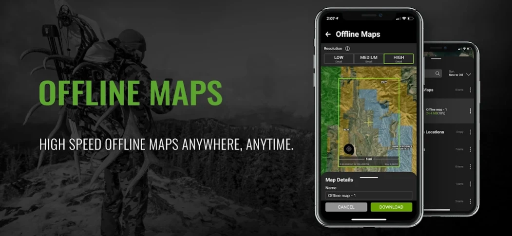
OFFLINE GPS and TRACKING
• Cache maps for offline use without service.
• Save as many offline maps as you want with unlimited caching (Pro).
• Know exactly where you are in real time even without cellular coverage.
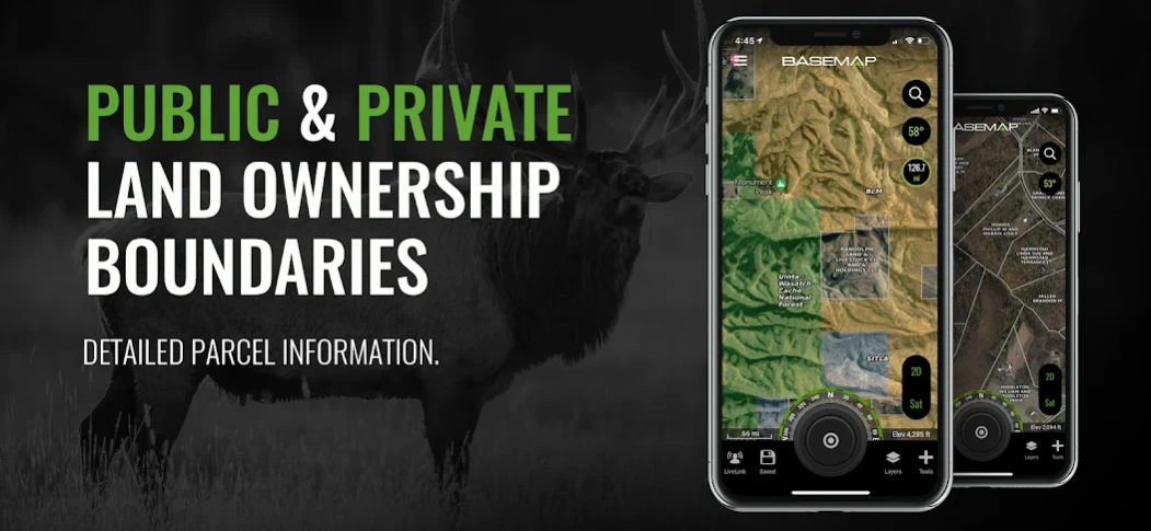
MAP LAYERS
• Over 800 layers and growing
• Nationwide Color Coded Govt Lands
• Nationwide Private Parcel Boundaries & Owner Names
• Water depths for East coast, West, Coast, Gulf coast, & over 4,000 U.S. lakes
• Nationwide Hiking Trails
• Nationwide Wildfires & Timbercuts
• Nationwide Wilderness & Roadless Areas
• State specific hunting layers including hunting unit boundaries, private hunting opportunities, WMA’s & more
• Multiple Topography & Satellite Imagery basemap options
• Much more
LRF MAPPING (Laser Rangefinder Mapping)
• Use your rangefinder as a powerful mapping tool
• Precisely mark the exact location of distant targets with ANY rangefinder
• Recover game, build routes, plan stalks, lookup distant property owners and more, all using your rangefinder!
MOBILE GPS
• Know your exact location even without cellular or WiFi service
• See where you are in relation to property boundaries, roads, trails, peaks, or boundaries
• Navigate to trail heads, favorite places, markers, or anything you need to locate with our powerful Search and GoTo features.
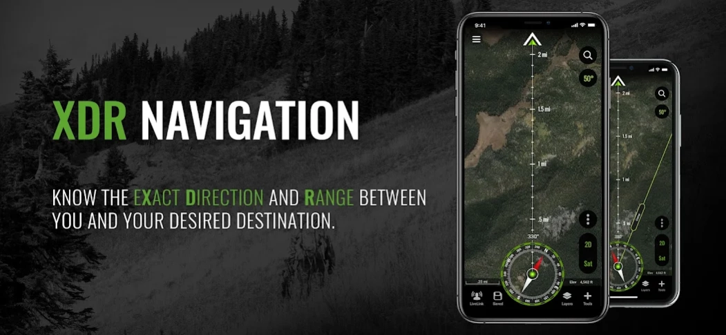
XDR (Exact Direction & Range) NAVIGATION TOOL
• Easy Point and Go navigation
• Know the exact distance between you and your destination.
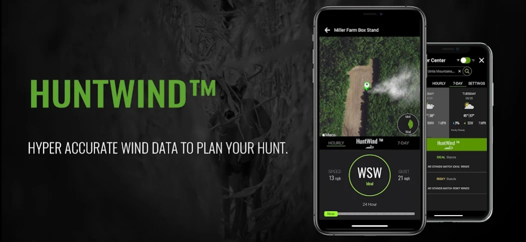
HUNTWIND™ & WEATHER CENTER
• Wind forecast to better plan your hunt.
• Know the exact day and time to hunt a particular stand and visualize wind direction and scent drift in relation to your location.
• Forecasts, temperature, moon phase, sunrise/sunset, wind, and more.
LOCATION SHARING
• Know exactly where your hunting partner is located
• Real-time updates
OUTDOOR JOURNAL
• Capture, log, and share all your outdoor adventures with the BaseMap community
• Real-time location sharing so friends can see where you are in case of emergency (connection reqd.)
• SmartMarkers - Automatically capture the weather conditions at the time you add a marker.
HARVEST LOG
• Log your hunts as detailed as you'd like. Record your hunt type, species/size, weapon, unit/GMU & much more.
GEARDROP
• Drop your marker closest to the GearDrop marker & win free gear.
GOOGLE EARTH INTEGRATION
• Export markers and view them right in Google Earth
• View the terrain in true 3D
DESKTOP APPLICATION
• Automatically sync all your data between your phone and the BaseMap web application.
SUBSCRIPTIONS
BASIC (Free)
• No Ads
• Connect with friends
• Hybrid 3D Imagery (map tilt).
• XDR Navigation
• Nationwide Roads, Trails & Points of Interest
• Nationwide Lakes, Rivers & Streams
• Hunting Unit boundaries
• GPS Location & Tracking
• Hi-Res Satellite Imagery
PRO ($34.99/yr)
• Everything in Basic plan
• Access to over 800 Layers
• Unlimited Data & Offline Use
• Nationwide parcel boundaries and owner names
• Nationwide color-coded government lands
• Google Earth Integration
• Import/Export KML and GPX with BaseMap web application
• Real-Time location sharing
• LRF Mapping (Laser Rangefinder Mapping)
PRO BUNDLE ($69.99/yr)
Includes:
• BaseMap Pro subscription
• HuntScore subscription for draw odds, harvest data, application tools, and more
• Global Rescue subscription for field advisory and rescue services
• $175 value
For questions or more information, contact us at: support@basemap.com
Privacy policy: https://www.basemap.com/privacy-policy/
Terms of use: https://www.basemap.com/terms-of-use/
About BaseMap: Hunting Maps and GPS
BaseMap: Hunting Maps and GPS is a free app for Android published in the Sports list of apps, part of Games & Entertainment.
The company that develops BaseMap: Hunting Maps and GPS is BaseMap Inc. The latest version released by its developer is 5.2.12.
To install BaseMap: Hunting Maps and GPS on your Android device, just click the green Continue To App button above to start the installation process. The app is listed on our website since 2023-10-24 and was downloaded 3 times. We have already checked if the download link is safe, however for your own protection we recommend that you scan the downloaded app with your antivirus. Your antivirus may detect the BaseMap: Hunting Maps and GPS as malware as malware if the download link to com.mobile.basemap is broken.
How to install BaseMap: Hunting Maps and GPS on your Android device:
- Click on the Continue To App button on our website. This will redirect you to Google Play.
- Once the BaseMap: Hunting Maps and GPS is shown in the Google Play listing of your Android device, you can start its download and installation. Tap on the Install button located below the search bar and to the right of the app icon.
- A pop-up window with the permissions required by BaseMap: Hunting Maps and GPS will be shown. Click on Accept to continue the process.
- BaseMap: Hunting Maps and GPS will be downloaded onto your device, displaying a progress. Once the download completes, the installation will start and you'll get a notification after the installation is finished.
